Flooding in My Town
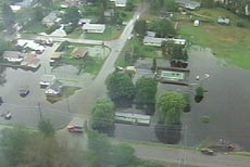
At first they said this was a picture of another town and then miraculously later in the day they correctly identified it as Grand Forks. We still aren't shown on the map lower down in the article. Weird thing is that we are the largest town affected by flooding.
Two pretty big rivers meet just above the top of the picture (hence the name Grand Forks). The one that comes from the north goes by our house, well, way out in front of our house. There is a big field and about 50 to 60 vertical feet between us and the river. But the field was 90% covered in water on Sunday. My son and his friend went canoeing on the new lake. Now it is only about 50% covered.
Grand Forks was a bustling place on Sunday, when the rivers reached their peak. Dumptrucks dumping loads of sand for people to fill sandbags, emergency crews out and about, sump pumps running, sandbagged homes and gawkers, both on two feet and in cars. Our normally quiet North Fork road had a steady stream of cars driving the 20 mile loop up to the Hummingbird Bridge and back to town. Pretty dramatic scenery when the normally beautifully green valley bottom turns to water. I have heard that the road past the bridge is washed out.
Mother Nature still rules.
posted by Muriel at 7:36 a.m.
![]()
1 Comments:
Hokey Smokes! I heard about the flooding in New England, but not up in B.C.! Well, of course, the myopic U.S. media -- "Canada? Where's that? I think I heard of it once..." Sheesh.
Post a Comment
<< Home